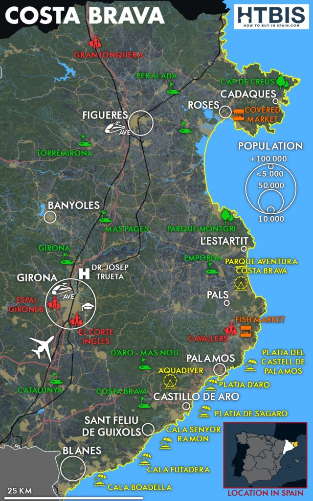
Costa Brava map information
- Airport: Girona – Costa Brava
- Ave stations: Girona, Figueres
- Cities: Girona (98,000 inhabitants), Figueres (45,700 inhabitants), Blanes (40,000 inhabitants), Cadaqués (3,000 inhabitants), Palamos (almost 20,000), Pals (2,500 inhabitants), L’Estartit (3,500 inhabitants), Platja d’Aro (over 10,000 inhabitants) and Sant Feliu de Guixols (22,000 inhabitants).
- Top beaches: Cala Senyor Ramon, Platja de s’Agaró, Cala Futadera, Platja del Castell de Palamos, Cala Boadella
- Kids Parks: Adventure Park Costa Brava, Aquadiver
- Shopping Malls & Outlets: Gran Jonquera (La Jonquera), Cavallers (palafrugell), El Corte Inglés (Girona), Espai Girones (Girona)
- Traditional & Flea markets: Fish Market (Palagrugell), Covered Market (Roses)
- Top golf courses: Golf de Catalunya (green fees between 70 and 150 €), Club Golf d’Aro, Mas Nou (green fees between 70 and € 100), the Emporda Golf Club (Greenfees between 68-79 €) and Club de Golf Costa Brava (green fees between 50-80 €), Play with the best golf clubs sets in Spain thanks to our local partner.
- Natural Parks: Natural Park Montgrí, Cap de Creus
- University: Universitat de Girona
- Hospital: Universitari Dr Josep Trueta
Don’t miss our dedicated article on the Costa Brava: Everything you ever wanted to know about the Costa Brava.
Monthly weather statistics for Girona, the Costa Brava
Find all our other detailed maps of the Spanish Costas and the Costa Brava.

FAQ Costa Brava Map
What is the nicest town in Costa Brava?
Cadaqués offers stunning whitewashed architecture and Salvador Dalí connections, while Tossa de Mar features medieval walls and beautiful beaches. Begur offers charming stone houses and secluded coves, such as Cala Futadera. Our Costa Brava map highlights each town's unique character.
What is Costa Brava famous for?
Costa Brava is famous for dramatic rocky coastlines, Salvador Dalí Triangle (Figueres, Port Lligat, Púbol), and excellent seafood cuisine. The region offers crystal-clear waters, medieval villages like Pals, and prestigious golf courses including Golf de Catalunya.
What are the best beaches on Costa Brava map?
Top beaches include Cala Senyor Ramon, Platja de s'Agaró, and Cala Futadera for secluded swimming. Platja del Castell (Palamós) and Cala Boadella offer excellent facilities. Our Costa Brava map shows precise locations and Blue Flag beaches.
Where is the best place to base yourself in Costa Brava?
Girona provides cultural richness and airport access (Girona-Costa Brava Airport). At the same time, Lloret de Mar offers excellent transportation links and a vibrant nightlife. Platja d'Aro combines beaches with amenities, and L'Escala offers authentic fishing village charm.
How far is Costa Brava from Barcelona and major airports?
Costa Brava is 60-150km from Barcelona, with Girona-Costa Brava Airport providing closest access. Barcelona Airport is located 100 km south, offering more international connections. Lloret de Mar is 90 minutes from Barcelona, Cadaqués 2 hours.
Which Costa Brava areas are best for families with kids?
Lloret de Mar offers Adventure Park Costa Brava and Aquadiver water parks. Blanes features botanical gardens and safe beaches, while L'Estartit offers boat trips to the Medes Islands. All areas offer family-friendly beaches and restaurants.
What are the best golf courses on Costa Brava?
Golf de Catalunya offers championship courses (€70-150 green fees), while Club Golf d'Aro and Empordà Golf Club provide scenic layouts (€68-79). Mas Nou and Costa Brava Golf Club offer more affordable options (€50-80).
Where does Costa Brava start and finish on the map?
Costa Brava stretches 214km from Blanes in the south to the French border at Portbou. The coastline covers Girona province, with major cities including Girona (98,000 inhabitants), Figueres (45,700), and Blanes (40,000).
How to get around Costa Brava using transport?
AP-7 motorway provides main access, while coastal roads connect beach towns. SARFA buses link all destinations, RENFE trains serve Girona and Figueres. Car rental from Girona-Costa Brava Airport offers coastal exploration flexibility.
What's the best time to visit Costa Brava?
May to September offers optimal weather with 22-28°C temperatures and minimal rainfall. July-August reaches 30°C peak season. April and October provide mild conditions with fewer crowds, while Costa Brava enjoys 300 sunny days annually.
Where are the Salvador Dalí sites on Costa Brava map?
Dalí Triangle includes Figueres Theatre-Museum (main collection), Port Lligat House (Cadaqués residence), and Púbol Castle (Gala's home). All sites are within 45 minutes, with Figueres accessible via high-speed train from Barcelona.
Where can you shop on Costa Brava?
Gran Jonquera outlet offers designer brands near French border, while El Corte Inglés and Espai Gironès serve Girona. Traditional markets include Fish Market (Palafrugell) and Covered Market (Roses) for local products and fresh seafood.

