Complete Spanish Costas Maps: Your Guide to All Spain’s Coastal Regions
Discover everything you ever dreamt of on the Spanish Costas with our comprehensive collection of Spanish Costas maps and detailed Costas guides. Our map of Spain Costas covers all coastal regions from the Mediterranean to the Atlantic, helping you explore Spain’s most beautiful shorelines.
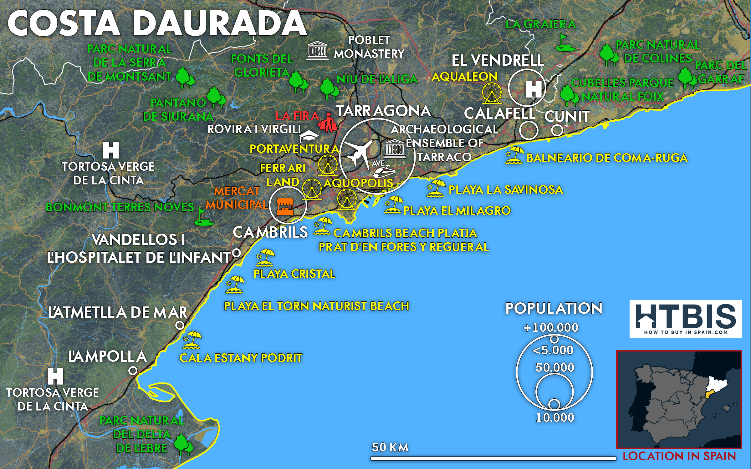
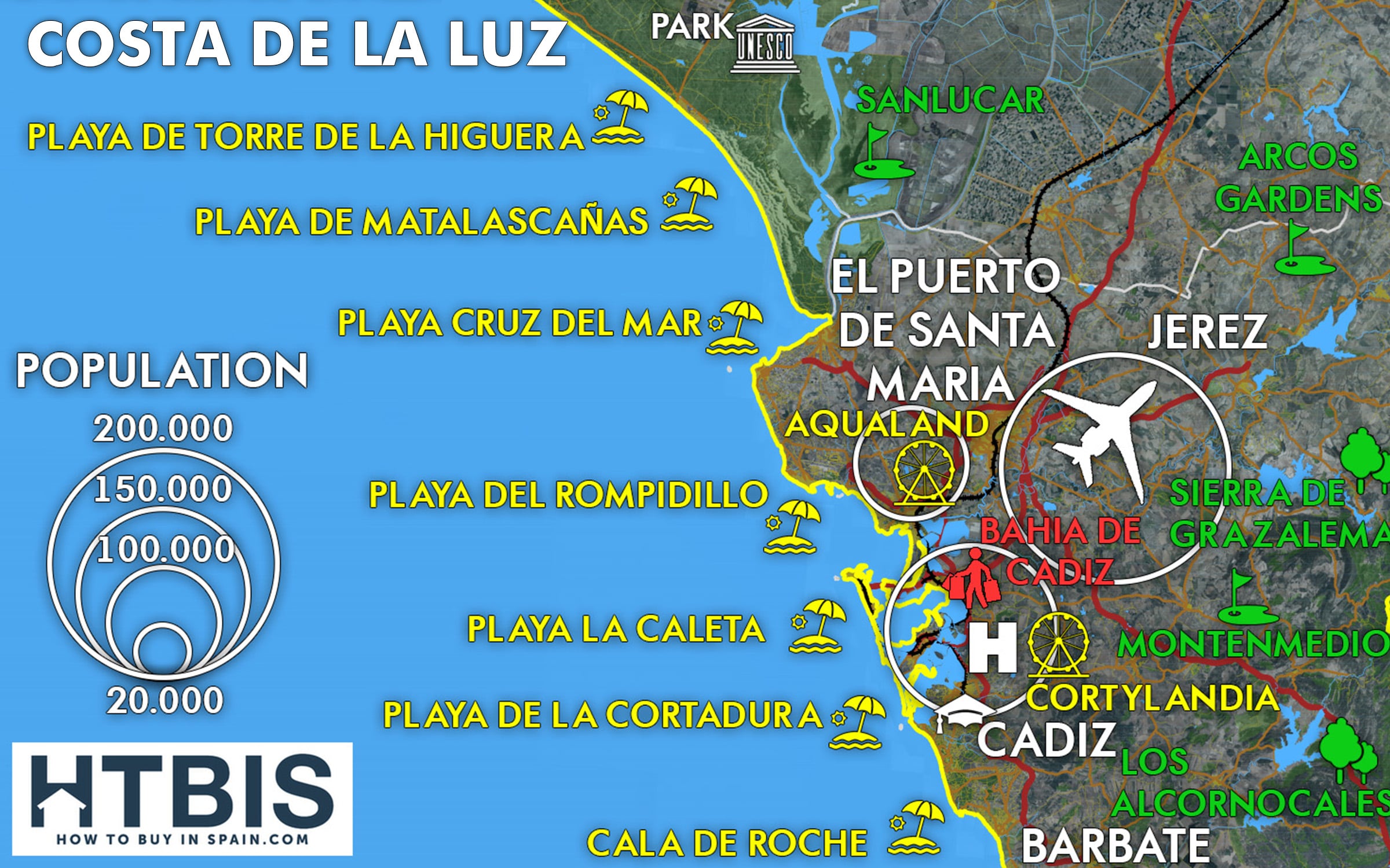
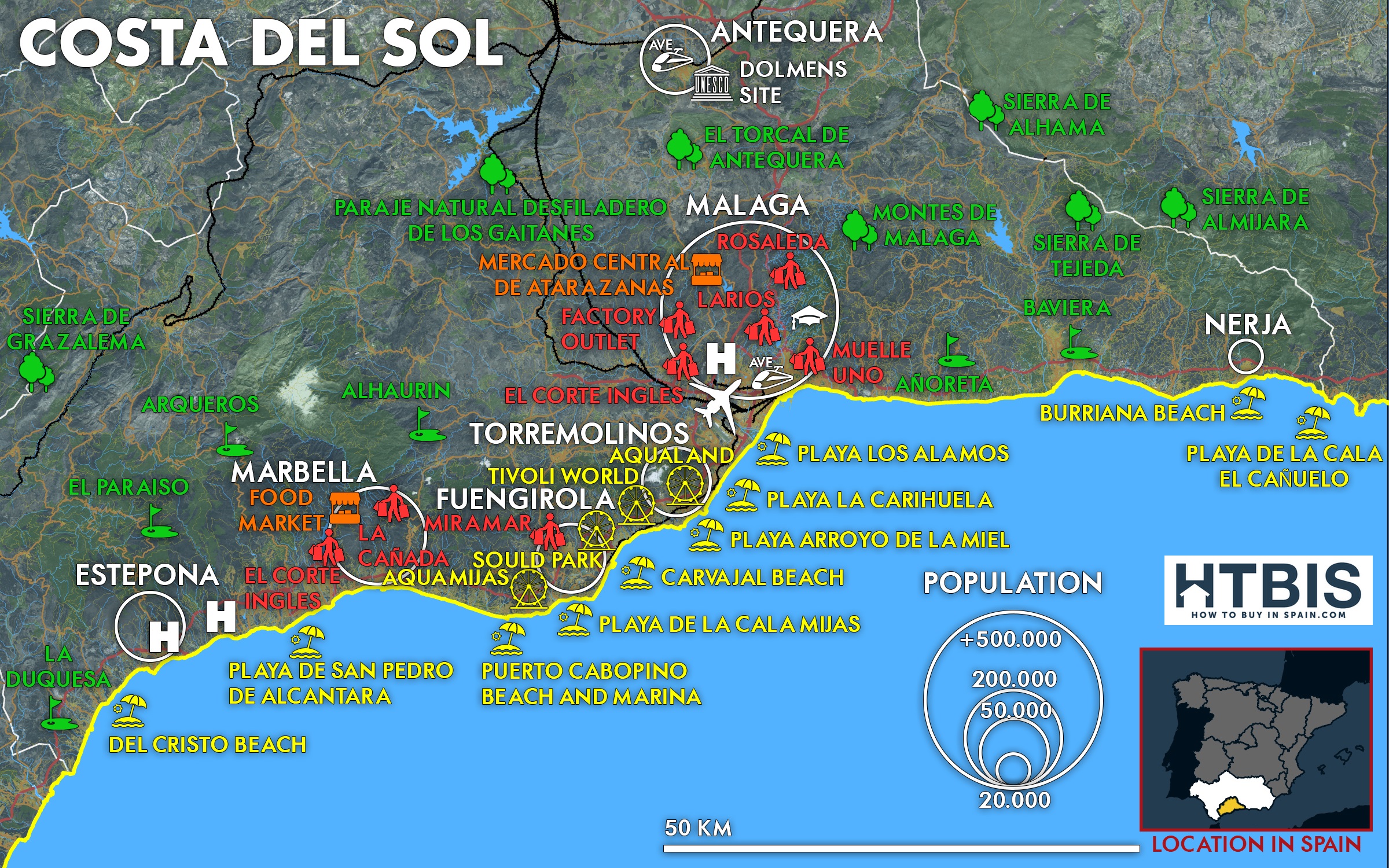
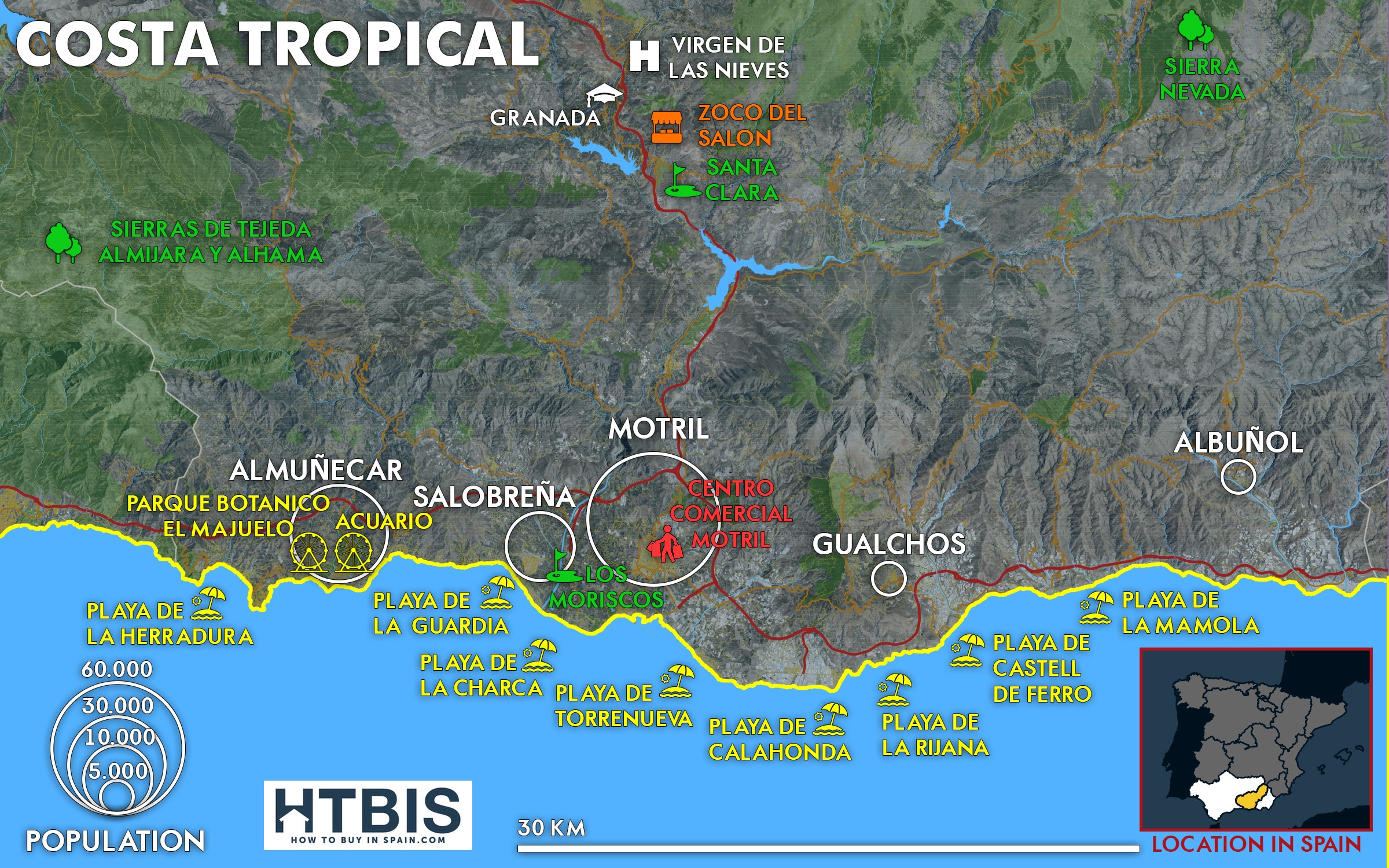
Each Costa guide includes essential information, such as international airports, AVE high-speed train stations, major cities, traditional markets, outlet shopping, UNESCO World Heritage sites, family attractions, national parks, championship golf courses, top universities, and pristine beaches.
️ CLICK ON ANY COSTA IMAGE to explore All Spanish Coastal Regions
From the famous Costa del Sol to the hidden gems of Costa Verde, our Spain costas map collection provides downloadable PDFs and comprehensive articles for every Spanish coastal destination.


Discover All Our Featured Spanish Coastal Regions
Our comprehensive collection covers Spain’s most popular coastal destinations. Each map of Spain showing Costas provides detailed guides to help you explore the different Costas in Spain we feature:
Mediterranean Costas
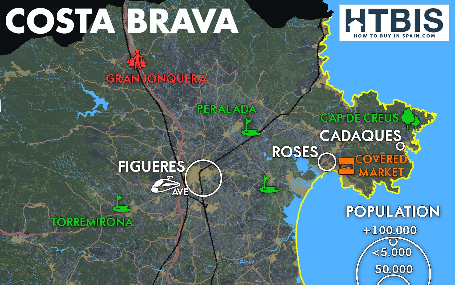
- Costa Brava map (Catalonia), Costa Brava article
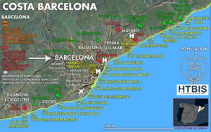
- Costa de Barcelona map (Catalonia),
- Costa Daurada map (Catalonia)
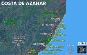
- Costa Azahar map (Valencia)
- Costa de Valencia map (Valencia)
- Costa Blanca map (Valencia)
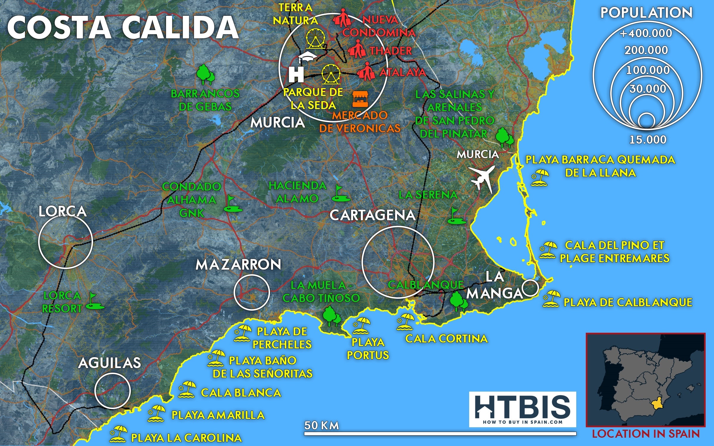
- Costa Cálida map (Murcia)
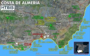
- Costa de Almería map (Andalusia)
- Costa Tropical map (Andalusia)
- Costa del Sol map (Andalusia)
Atlantic Costa & Islands
- Costa de la Luz map (Andalusia)
️ Spanish Islands
Each region includes detailed maps, guides, and downloadable PDFs
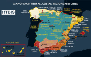
Where Are the Costas in Spain? Our Featured Regions
Our detailed Costas in Spain map collection covers the most popular Spanish coastal destinations across three main areas:
- Eastern Mediterranean Coast: From Costa Brava (French border) to Costa Cálida (Murcia), including Costa de Barcelona, Costa Daurada, Costa Azahar, Costa de Valencia, and Costa Blanca
- Southern Mediterranean: Costa de Almería, Costa Tropical, and the famous Costa del Sol
- Atlantic Southwest: Costa de la Luz facing Morocco and Portugal
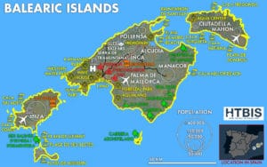
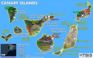
- Spanish Islands: The Balearic Islands (Mediterranean) and The Canary Islands (Atlantic)
Planning Your Costa Adventure?
Use our maps of the Costas to compare climate, attractions, and accessibility. Each Costa offers unique experiences – from the Costa Brava’s artistic heritage to the Costa del Sol’s golf courses and the Costa Verde’s pristine nature.
Pro Tip: Download our PDF guides to access offline maps, transportation networks, and insider recommendations for each coastal region.
Essential Weather Information for Spanish Coastal Planning
Understanding climate patterns across the different Costas in Spain is crucial for planning visits, relocations, or investments. Our weather guides complement the Costa’s map Spain collection with detailed meteorological data.

Climate Guide for Our Featured Costas:
- Mediterranean Costas: Warm, dry summers; mild winters (300+ sunny days annually)
- Costa de la Luz: Year-round mild Atlantic temperatures; more rainfall in winter
- Balearic Islands: Classic Mediterranean climate with sea breezes
- Canary Islands: Subtropical climate with minimal seasonal variation
Ready to Explore Spanish Costas?
Whether you’re seeking Costas in Spain for vacation, relocation, or investment, our comprehensive map of Spain’s Costas provides everything needed for informed decision-making.
Start exploring: Click any Costa image above to access detailed maps, transportation guides, attraction lists, and investment insights. Each guide includes downloadable PDFs for offline reference.
FAQ Spanish Costas
Which is the nicest costa in Spain?
The most popular costas include Costa del Sol (year-round sunshine), Costa Brava (dramatic cliffs and villages), Costa Blanca (white sand beaches), Balearic Islands (Mediterranean paradise), and Canary Islands (subtropical climate). Each costa offers unique attractions detailed in our spanish costas maps.
Where are all the costas in Spain located?
Our map of spain costas covers 13 regions: 11 mainland costas from Costa Brava (French border) to Costa de la Luz (Portuguese border), plus the Balearic Islands (Mediterranean) and Canary Islands (Atlantic). Each costas in spain map shows exact locations and transportation.
How many costas are there in Spain that you cover?
Our spanish costas maps feature 13 coastal regions: 11 mainland costas plus 2 island costas (Balearic Islands and Canary Islands). Each spain costas map provides detailed guides for the most popular Spanish coastal destinations.
What is the nicest part of the Spanish coast for beaches?
Top beach destinations include Costa del Sol (luxury resorts), Costa Brava (crystal-clear waters), Costa Blanca (family-friendly), Balearic Islands (Europe's most beautiful island beaches), and Canary Islands (volcanic black sand beaches). Our different costas in spain guides help you choose.
How can I use your Spanish costas maps for trip planning?
Our interactive spain map of costas shows major airports, distances between regions, and detailed guides. Each map includes transportation networks, beaches, golf courses, and downloadable PDFs for comprehensive trip planning and offline reference.
