Map of Spain: Your Ultimate Guide to Spanish Regions, Costas and Cities
Navigate Spain’s stunning coastlines with our comprehensive map of Spain featuring all major regions, cities, and coastal areas. This detailed spain map regions guide serves as your gateway to understanding Spanish geography before making important decisions about where to visit, live, or invest.
Here’s what we’ve prepared to assist you in discovering your perfect Spanish coastal destination:
- Complete Overview Map – Locate all 17 regions, major cities, and famous costas at a glance
- Downloadable PDF Maps – Detailed guides for each coastal region
- In-depth Articles – Comprehensive information about every costa
- Travel Planning Tools – Airports, train stations, and transportation networks
- Investment Insights – Emerging areas and property market analysis
Perfect for:
- Vacation Planning – Compare beaches, attractions, and activities
- Relocation Research – Understand living costs, climate, and infrastructure
- Investment Opportunities – Identify promising coastal property markets
Whether you’re planning a vacation, considering relocation, or exploring investment opportunities, this detailed spain costas map collection provides the foundation for successful decision-making. Start with our overview map, then dive deep into specific coastal regions that match your interests and requirements.
Each region offers unique characteristics, and our detailed spain map cities guide helps you plan efficient travel routes, compare different coastal regions, and discover the perfect Spanish coastal destination for your needs.
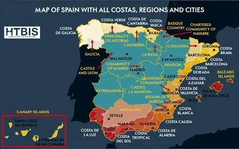
Locate Spain’s Key Cities, Regions and Costas
This detailed map of spain with cities showcases the country’s diverse geography. Additionally, it helps you locate the most popular destinations, though many more cities and regions appear throughout the interactive map:
️ Top Spanish Cities
- • Madrid (3.2M inhabitants)
- • Barcelona (1.6M inhabitants)
- • Valencia (800K inhabitants)
- • Seville (690K inhabitants)
- • Zaragoza (675K inhabitants)
Plus dozens more cities marked on the map
️ Main Spanish Regions
- • Andalusia (southern Spain)
- • Catalonia (northeast coast)
- • Valencia Community (east coast)
- • Madrid Community (central)
- • Galicia (northwest coast)
All 17 autonomous communities shown
️ Most Famous Costas
- • Costa del Sol (Andalusia)
- • Costa Brava (Catalonia)
- • Costa Blanca (Valencia)
- • Costa de la Luz (Andalusia)
- • Costa Verde (northern Spain)
Plus additional coastal regions included
This interactive spain regions map provides a clear overview of all 17 autonomous communities, major transportation hubs, and the complete map of spain costas. Moreover, it serves as your starting point for detailed costa exploration.
Your Ultimate Guide to Each Spanish Costa
The Spanish costas offer some of Europe’s most desirable beachfront locations. To assist you further in discovering your Spanish coastal paradise, we’ve created dedicated costa maps with comprehensive information. Each detailed spain costas map includes both downloadable PDF guides and in-depth articles covering essential information for residents, investors, and visitors:
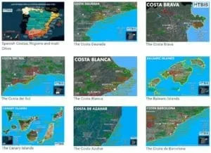
Explore each Spanish costa in detail – Access comprehensive maps, downloadable PDFs, and complete regional guides for every coastal area
What You’ll Discover in Each Costa Guide:
- Transportation Networks: International airports, AVE high-speed train stations, and regional connectivity options
- Essential Infrastructure: Major cities with population statistics, universities, hospitals, and public services
- Coastal Attractions: Top-rated beaches, natural parks, marine reserves, and waterfront destinations
- Recreation Facilities: Championship golf courses, family attractions, sports facilities, and outdoor activities
- Shopping Destinations: Traditional markets, artisan fairs, modern shopping centers, and outlet villages
- Cultural Heritage: UNESCO World Heritage sites, museums, historic landmarks, and local festivals
- Investment Opportunities: Real estate market analysis, emerging areas, and property investment insights
- Climate Information: Monthly weather patterns, seasonal variations, and optimal visiting times
Furthermore, each costa guide includes practical information about local dining, nightlife, and hidden gems that only locals know about. Consequently, you’ll have everything needed to make informed decisions about visiting, living, or investing in Spanish coastal regions.
Ready to Start Your Spanish Costa Discovery?
While this comprehensive map spain overview helps you locate regions and understand Spanish geography, each costa offers detailed maps, downloadable PDF guides, and comprehensive articles. Subsequently, you can explore everything from the best beaches and golf courses to shopping destinations and real estate opportunities.
FAQ on Spanish regions
What are the 5 main regions of Spain on the map?
The 5 largest regions on our Spain map are Andalusia (home to Costa del Sol), Catalonia (featuring Costa Brava), Castile and León (central-northwest), Castile-La Mancha (central), and Valencia Community (including Costa Blanca). Our detailed map shows all 17 autonomous communities with coastal areas.
What is the prettiest region of Spain for coastal areas?
The prettiest coastal regions include Andalusia (Costa del Sol), Catalonia (Costa Brava), Valencia (Costa Blanca), plus the Balearic Islands and Canary Islands. Our spain costas map provides detailed information about each region's unique beauty and attractions.
Where is the nicest part of Spain to visit for beaches?
Top beach destinations include Costa del Sol (vibrant nightlife), Costa Brava (charming villages), Costa Blanca (family-friendly resorts), Balearic Islands (crystal-clear waters), and Canary Islands (year-round swimming). Our spain map regions guide helps you compare all destinations.
What are the most popular Spanish costas shown on the map?
Our most popular costas include Costa del Sol, Costa Brava, Costa Blanca, Costa de la Luz, Costa de Almería, Costa Tropical, Costa Daurada, Balearic Islands, and Canary Islands. Each offers distinct characteristics detailed in our downloadable costa guides.
How can I use this Spain map to plan my coastal trip?
Our interactive map shows major airports, train stations, and highways near each costa. Identify closest cities (Barcelona for Costa Brava, Málaga for Costa del Sol), compare distances, and access detailed guides with transportation, beaches, and climate information.

Whether you’re planning a vacation, considering relocation, or exploring investment opportunities, this comprehensive regions of spain map serves as your gateway to understanding Spanish geography and making informed decisions about your Spanish coastal adventure.